-
 Fishing Info
» MN DNR -
 Outdoor Recreation Map
» MN DNR -
 Lake Finder
» MN DNR -
 Fish Finder (Desktop Recommended)
» MN DNR -
 Aquatic Management Areas
» MN DNR -
 Water Clarity Finder
» UofM -
 Seasons (Fishing)
» MN DNR -
Seasons & Limits Guide: Calendar Style (Fishing)
» Bendare Outdoors -
This quick-view, calendar style Minnesota fishing seasons and limits guide, by Bendare Outdoors, is available as a FREE PDF in different versions based on water body and species.
This guide is organized in a simple monthly layout that helps you find what you are looking for quickly. It provides information on fishing all species in Minnesota's waters, including: inland lakes, rivers and streams, Lake Superior and its tributaries, and Minnesota's many border waters (Canada, Wisconsin, Iowa and the Dakotas). User and printer-friendly.
Wishing you tight lines and bent rods!

-
 Regulations (Fishing)
» MN DNR -
 License (Fishing)
» MN DNR -
Boating Regulations
» MN DNR -
Watercraft License & Fees
» MN DNR -
 FIN: Fishing in Neighborhoods (Metro)
» MN DNR -
 Fish Species
» Bendare Outdoors -
Fish ID & Tips Guide
» MN DNR -
 Redhorse ID
» Moxostoma .com -
 ID Guide: Trout & Salmon (LS)
» MISG -
Some trout species are open year-round in parts of southeast Minnesota and in Lake Superior and its tributaries below the posted boundaries!
There are several other trout dates and regulations to remember based on the time of year and whether it's a lake, river or stream. Use Bendare's Trout & Salmon Fishing Seasons and Limits guide for the quickest and easiest way to know MORR! Happy troutin'!
-
Trout Waters
» MN DNR -
Designated Trout Waters
» MN.gov -
 Trout Fishing in Southeastern MN
» MN DNR -
Southeastern Trout Map
» MN DNR -
Southeastern Trout Lakes
» MN DNR -
Southeastern Trout Streams
» MN DNR -
 Trout & Salmon Guide: Lake Superior & North Shore (Duluth to Beaver Bay)
» MN DNR -
Trout & Salmon Guide: Lake Superior & North Shore (Beaver Bay to Hovland)
» MN DNR -
North Shore Fishing (LS)
» MN DNR -
 North Shore Fishing Techniques (LS)
» MN DNR -
 Lake Superior Streams
» LakeSuperior Streams.org -
 Lake Superior Surface Temps (Recent)
» NOAA -
 Lake Superior Wind & Waves (Current & Forecasts)
» Windfinder -
 Lake Superior Western Buoy Data (Current)
» UMD -
 Lake Superior Satellite Images (Recent)
» NOAA -
 State Water Trails
» MN DNR -
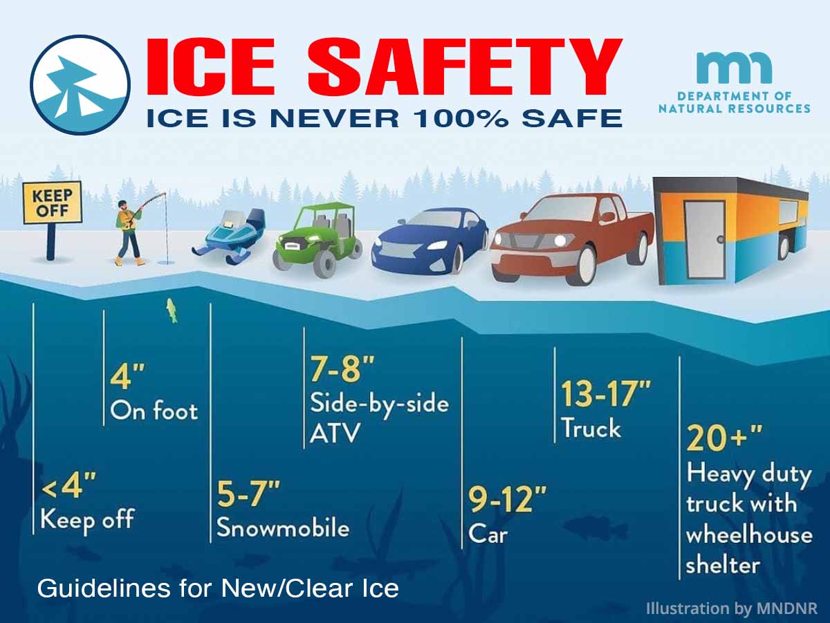
 Ice Fishing
» Explore MN -
 Ice Out Status
» MN DNR -
 River Levels & Forecasts
» NOAA/NWS -
 River Levels (State Water Trails)
» MN DNR -
 State Record Fish
» MN DNR -
 Fishing Contests
» MN DNR -
 Aquatic Invasive Species
» MN DNR -
 Infested Waters List
» MN DNR -
 Fish Consumption Guidance
» MN Dept. of Health -
Wild Minnesota Recipe Exchange
» MN DNR -
 Lead-Free Tackle
» MPCA -
 American Currents Articles (1972-Present)
» NANFA -
MN Fishing Outlooks
» MN DNR -
Lake Superior Fishing Reports
» MN DNR -
How to Catch Fish
» MN DNR -
 Fishing Webinars
» MN DNR
This quick-view, calendar style Minnesota Trout & Salmon fishing seasons and limits guide, by Bendare Outdoors, is available as a FREE PDF in different versions based on water body and species.
This guide is organized in a simple monthly layout that helps you find what you are looking for quickly. It provides information on fishing all species in Minnesota's waters, including: inland lakes, rivers and streams, Lake Superior and its tributaries, and Minnesota's many border waters (Canada, Wisconsin, Iowa and the Dakotas). User and printer-friendly.
Wishing you tight lines and bent rods!
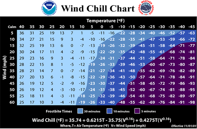 Wind Chill Chart